What Are Drones Used For in Agriculture?

Drones are revolutionizing agriculture, offering farmers unprecedented insights and efficiencies through aerial data collection and targeted interventions. From crop health monitoring to precision spraying, these unmanned aerial vehicles are transforming farming practices, leading to higher yields, reduced costs, and more sustainable operations.

The Drone’s Eye View: Revolutionizing Farming
Modern agriculture is constantly seeking innovative ways to optimize resource utilization and maximize yields. Drones, or unmanned aerial vehicles (UAVs), have emerged as a powerful tool in achieving these goals. Their ability to capture high-resolution aerial imagery and deploy specialized sensors provides farmers with invaluable data, leading to more informed decision-making across all stages of the agricultural cycle. Forget outdated and costly aerial photography; drones offer a nimble, affordable, and highly adaptable solution.
Key Applications of Drones in Agriculture
Drones are not simply toys; they are sophisticated pieces of technology contributing significantly to modern farming. Their application spans multiple crucial areas:
- Crop Health Monitoring: Using multispectral and hyperspectral cameras, drones can assess plant health by analyzing light reflectance patterns. This allows farmers to identify areas of stress due to nutrient deficiencies, disease outbreaks, or pest infestations early and accurately. This timely detection allows for swift intervention, preventing widespread crop damage.
- Field Mapping and Surveying: Drones equipped with GPS and LiDAR technology can create detailed maps of fields, including elevation models and contour lines. This information is crucial for planning irrigation systems, optimizing drainage, and identifying areas prone to erosion. These maps also allow for precise input application, reducing waste and improving efficiency.
- Precision Irrigation: Drones can identify areas of moisture stress in fields, allowing for targeted irrigation. This precision approach minimizes water waste and ensures that crops receive the optimal amount of hydration, leading to healthier plants and higher yields.
- Livestock Management: Drones equipped with thermal cameras can monitor livestock, detecting sick or injured animals that may be separated from the herd. They can also be used to track livestock movements, ensuring that animals are grazing in designated areas and preventing overgrazing.
- Yield Estimation: By analyzing aerial imagery, drones can estimate crop yields before harvest. This information helps farmers plan for storage, transportation, and marketing, minimizing post-harvest losses.
- Pest and Disease Detection: Drones can scout fields for signs of pests and diseases, allowing farmers to implement targeted control measures. This reduces the need for broad-spectrum pesticide applications, minimizing environmental impact and promoting sustainable farming practices.
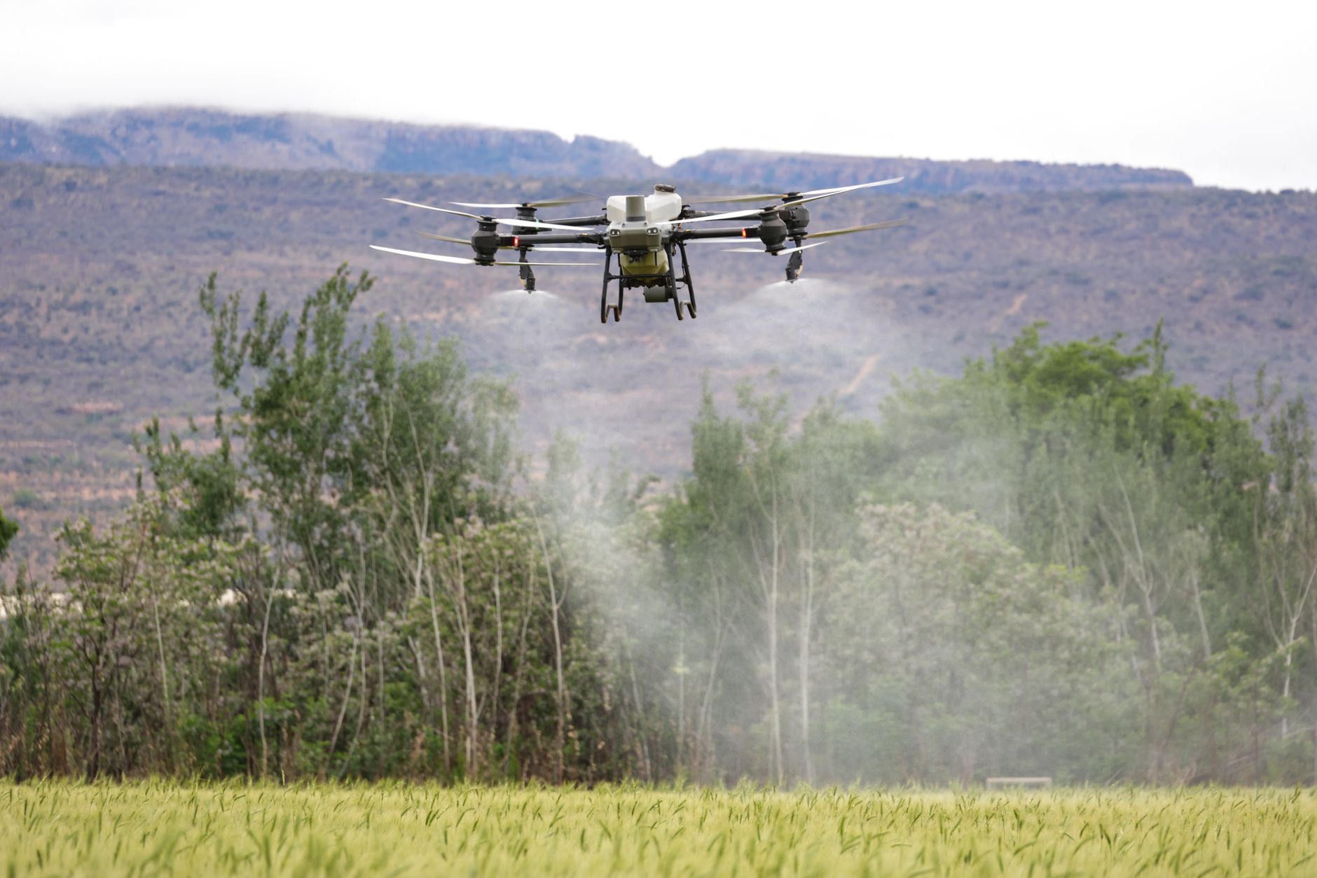
- Precision Spraying: Drones can be equipped with spraying systems to apply pesticides, herbicides, and fertilizers in a highly targeted manner. This minimizes the amount of chemicals used, reducing costs and environmental impact. Precise application reduces drift and ensures that chemicals are applied only where they are needed.
Benefits of Using Drones in Agriculture
The adoption of drone technology in agriculture offers numerous benefits:
- Increased Efficiency: Drones automate many tasks that were previously performed manually, saving time and labor.
- Reduced Costs: Precision agriculture practices enabled by drones minimize input costs, such as fertilizer, pesticides, and water.
- Improved Yields: Early detection of problems and targeted interventions lead to healthier crops and higher yields.
- Environmental Sustainability: Minimizing the use of chemicals and water promotes more sustainable farming practices.
- Better Decision-Making: Data-driven insights empower farmers to make more informed decisions about crop management.
The Future of Drones in Agriculture
As drone technology continues to evolve, we can expect to see even more innovative applications in agriculture. Developments in artificial intelligence, sensor technology, and battery life will further enhance the capabilities of drones, making them an even more indispensable tool for farmers. We’ll see more sophisticated data analysis, fully automated drone operations, and seamless integration with other agricultural technologies.
Frequently Asked Questions (FAQs)
Q1: What types of sensors are commonly used on agricultural drones?
The most common sensors include: RGB cameras (for visual imagery), multispectral cameras (for assessing plant health), hyperspectral cameras (for detailed plant analysis), thermal cameras (for detecting temperature variations, useful for irrigation management and livestock monitoring), and LiDAR sensors (for creating 3D maps of fields). Each sensor provides different types of data valuable for different applications.

What colours are fish most attracted to?
Can you put your finger in a trout's mouth?
Is methylene blue anti bacterial?
Does aquarium salt raise pH in aquarium?
Q2: How much does it cost to implement drone technology in agriculture?
The cost varies depending on the type of drone, the sensors it carries, and the software used for data processing. Entry-level drones with basic RGB cameras can cost a few thousand dollars, while more sophisticated drones with advanced sensors can cost tens of thousands of dollars. Furthermore, the cost of training, maintenance, and data processing software must be considered. Leasing options can reduce initial investment costs.
Q3: Do I need a license to fly a drone for agricultural purposes?
In many countries, including the United States, you need to obtain a drone pilot certificate (e.g., FAA Part 107 in the US) to fly a drone for commercial purposes, including agriculture. Regulations vary by country, so it is essential to check the specific requirements in your area. Furthermore, restrictions and regulations can vary depending on the weight of the drone and location of the flight.
Q4: How long can a drone typically fly on a single battery charge?
Flight time varies depending on the drone’s size, weight, and battery capacity, as well as wind conditions. Most agricultural drones can fly for 20-40 minutes on a single charge. Newer models are constantly improving battery life, and some can now fly for over an hour. Having multiple batteries on hand is crucial for uninterrupted operation.
Q5: What kind of data processing software is used with agricultural drones?
Various software packages are available for processing drone imagery and generating actionable insights. Popular options include Pix4D, DroneDeploy, Agisoft Metashape, and PrecisionHawk. These software platforms can create orthomosaics, digital elevation models, and vegetation indices, which are used to assess crop health, map fields, and plan irrigation.
Q6: How does drone data help with precision irrigation?
Drones equipped with thermal cameras can identify areas of moisture stress in fields by detecting differences in plant temperature. Stressed plants will typically have a higher temperature. This data can be used to create irrigation maps that direct water only to the areas that need it most, optimizing water use and improving crop health.
Q7: Can drones be used to apply pesticides and herbicides?
Yes, spraying drones are increasingly used to apply pesticides, herbicides, and fertilizers in a targeted manner. These drones are equipped with specialized spraying systems that can deliver chemicals directly to the plants that need them, minimizing drift and reducing the overall amount of chemicals used. Local regulations on drone spraying must be followed carefully.
Q8: What are the limitations of using drones in agriculture?
Limitations include weather dependency (drones cannot fly in heavy rain or strong winds), battery life, regulatory restrictions, initial investment costs, and the need for skilled operators to fly the drones and interpret the data.
Q9: How accurate is drone data for crop health assessment?
The accuracy of drone data for crop health assessment depends on the quality of the sensors, the altitude of the flight, and the data processing methods used. When properly calibrated and processed, drone data can provide a highly accurate assessment of crop health, allowing for early detection of problems and timely interventions.
Q10: How can I get started using drones on my farm?
Start by researching the different types of drones and sensors available and determining which ones best suit your specific needs. Then, obtain the necessary licenses and training. Consider starting with a smaller drone and a basic set of sensors and gradually expanding your capabilities as you gain experience. Many universities and agricultural extension services offer workshops and training programs on drone technology.
Q11: What is NDVI, and how is it used in agriculture with drones?
NDVI (Normalized Difference Vegetation Index) is a widely used index for assessing plant health. It is calculated from the red and near-infrared wavelengths of light reflected by plants. Healthy plants absorb more red light and reflect more near-infrared light, resulting in a higher NDVI value. Drones equipped with multispectral cameras can capture these wavelengths, allowing farmers to create NDVI maps that identify areas of healthy and stressed vegetation.
Q12: Are there any privacy concerns associated with using drones in agriculture?
Yes, privacy concerns can arise if drones are used to collect data on neighboring properties or individuals without their consent. It is important to respect the privacy of others and comply with all applicable laws and regulations regarding data collection and privacy. Transparency with neighboring landowners can mitigate concerns.